Atlas

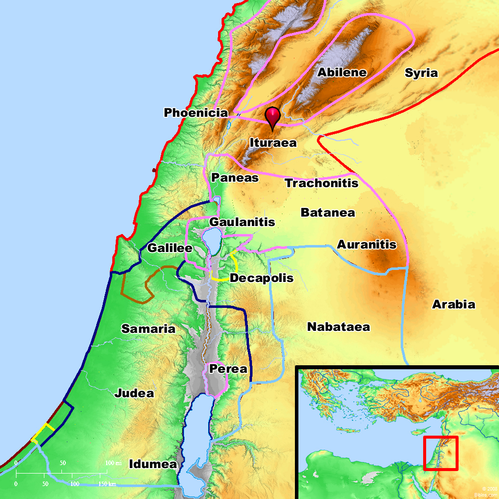
Ituraea and surrounding region
Maps Created using Biblemapper 3.0Additional data from OpenBible.info
You are free to use up to 50 Biblos coprighted maps (small or large) for your website or presentation. Please credit Biblos.com.
Occurrences
Luke 3:1 Now in the fifteenth year of the reign of Tiberius Caesar, Pontius Pilate being governor of Judea, and Herod being tetrarch of Galilee, and his brother Philip tetrarch of the region of Ituraea and Trachonitis, and Lysanias tetrarch of Abilene,
Encyclopedia
ITURAEAit-u-re'-a (Itouraia):
1. The Word an Adjective:
The term occurs only once in Scripture, in the definition of Philip's territory: tes Itouraias kai Trachonitidos choras, which the King James Version renders: "of Ituraea and of the region of Trachonitis," and Revised Version: "the region of Ituraea and Trachonitis" (Luke 3:1). Sir W.M. Ramsay has given reasons for the belief that this word was certainly never used as a noun by any writer before the time of Eusebius (Expos, 1894, IX, 51, 143, 288). It must be taken as an adjective indicating the country occupied by the Itureans.
2. The Itureans:
The descent of the Itureans must probably be traced to Jetur, son of Ishmael (Genesis 25:15), whose progeny were clearly numbered among the Arabian nomads. According to Eupolemus (circa 150 B.C.), quoted by Eusebius (Praep. Evang. IX, 30), they were associated with the Nabateans, Moabites and Ammonites against whom David warred on the East of the Jordan. They are often mentioned by Latin writers; their skill in archery seems greatly to have impressed the Romans. They were skillful archers (Caesar, Bell. Afr. 20); a lawless (Strabo, xvi.2, 10) and predatory people (Cicero, Philipp. ii.112). In the Latin inscriptions Iturean soldiers have Syrian names (HJP, I, ii, 326). They would therefore be the most northerly of the confederates opposed to David (supra), and their country may naturally be sought in the neighborhood of Mt. Hermon.
3. Indications of Their Territory:
There is nothing to show when they moved from the desert to this district. Aristobulus made war against the Itureans, compelled many of them to be circumcised, and added a great part of their territory to Judea, 140 B.C. (Ant., XIII, xi, 3). Dio Cassius calls Lysanias "king of the Itureans" (xlix.32), and from him Zenodorus leased land which included Ulatha and Paneas, 25 B.C. The capital of Lysanias was Chalcis, and he ruled over the land from Damascus to the sea. Josephus speaks of Soemus as a tetrarch in Lebanon (Vita, 11); while Tacitus calls him governor of the Itureans (Ann. xii.23). The country of Zenodorus, lying between Trachonitis and Galilee, and including Paneas and Ulatha, Augustus bestowed on Herod, 20 B.C. (Ant., XV, x, 3). In defining the tetrarchy of Philip, Josephus names Batanea, Trachonitis and Auranitis, but says nothing of the Itureans (Ant., XVII, xi, 4; BJ, II, vi, 3). Paneas and Ulatha were doubtless included, and this may have been Iturean territory (HJP, I, ii, 333). It seems probable, therefore, that the Itureans dwelt mainly in the mountains, and in the broad valley of Coele-Syria; but they may also have occupied the district to the Southeast of Hermon, the modern Jedur. It is not possible to define more closely the Iturean country; indeed it is not clear whether Luke intended to indicate two separate parts of the dominion of Philip, or used names which to some extent overlapped.
It has been suggested that the name Jedur may be derived from the Hebrew yeTur, and so be equivalent to Ituraea. But the derivation is impossible.
W. Ewing
Strong's Greek
G2484: ItouraiosIturaea, a region North of Pal.


